In Archeofoss 2020, Julian Bogdani presented a discussion on methodological issues and practical solutions regarding the development and publication of open standards for the vectorization of archaeological and architectonic topographic legacy data (abstract in https://zenodo.org/record/4002961#.YHgzlOgzaUk).
To design specific cartographic and topographic themes fit for publication, there is a need to have maps of various scales digitized, vectorized and georeferenced. Usually, this material is quite heterogeneous depending on multiple aspects: scale, graphical styling and topographic accuracy. Therefore, the degree of interpretation and reconstructive hypothesis varies greatly from one map to another.
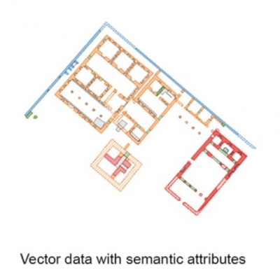
These processes entail risks, primarily creating a CAD-based, muted vector theme, a sort of digital-analogical copy of the paper version. Thus, in the Atlas (https://atlas.paths-erc.eu), it was decided to enrich the vector features with semantics, through the drafting of a simple but powerful schema able to encode concisely but exhaustively all sorts of information that a common archaeological and/or architectonic sketch is able to convey.
This approach considers the georeferencing and vectorization processes not as a purely mechanical or “join-the-dots” task, but as a critical archaeological reading and interpretation of the original drawing and its translation into digital format.
The resulting protocol named PAThs Simple Vectorization Protocol, or simply SVP, has been released as a Free Cultural Work with the Creative Commons Attribution 4.0 International License.
It’s possible to review this presentation on youtube: https://www.youtube.com/watch?v=OPt3XURTP0g
Follow us on our social network!
Copia qui lo "short link" a questo articolo
www.archeomatica.it/{sh404sef_shurl}